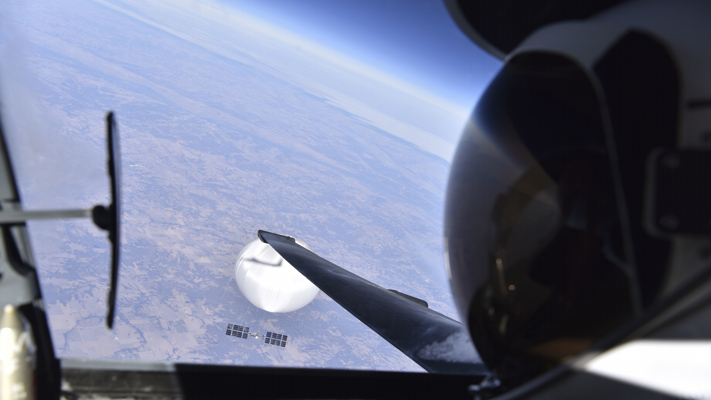
A U.S. Air Force pilot looked down at the suspected Chinese surveillance balloon as it hovered over the Central Continental United States February 3, 2023. The pair was flying over Bellflower, Missouri. Department of Defense hide caption
toggle caption
Department of Defense

A U.S. Air Force pilot looked down at the suspected Chinese surveillance balloon as it hovered over the Central Continental United States February 3, 2023. The pair was flying over Bellflower, Missouri.
Department of Defense
It’s arguably the greatest selfie ever taken. A pilot aboard the Air Force’s legendary U-2 spy plane is looking down at China’s alleged spy balloon as it hovers somewhere over the United States.
The photo, taken on Feb. 3 and released by the Department of Defense on Wednesday, has reportedly reached legendary status inside the Pentagon.
But where, exactly, was it taken?
In a world with very few secrets, it’s actually possible to answer that question.
The balloon and the U-2 spy plane were just south of the tiny city of Bellflower, Missouri, population 325, according to the U.S. Census.
Bellflower is just visible in the lower left hand corner of the image.
It’s clearly identifiable from its distinctive reservoir and a nearby agricultural supply business just north of town. pic.twitter.com/628a9x3ITD
— Geoff Brumfiel (@gbrumfiel) February 23, 2023
So, if you’re curious, how does one go about locating a supposed spy balloon?
It’s actually not an impossible task, and I laid my process in a Twitter thread earlier today (Another Twitter user reached the same conclusion several hours earlier).
For starters, it is possible to look up roughly where the balloon was on the date the military said the photo was taken, Feb. 3. There were several reports of the balloon passing over the Midwest, moving from near Kansas City towards St. Louis.
Next, check for landmarks in the photo. Far off on the horizon there’s a river which is clearly visible, along with some high altitude clouds. A quick review of publicly available satellite data revealed there was a front of clouds along the Mississippi River that day.
Turns out that’s the mighty Mississippi.
So great candidate, but kind of a big river.
I started looking for features that might give a more specific point. And I settled on this funny Y of either tributaries or irrigation canals. There also appeared to be a bridge or a dam… pic.twitter.com/zl1Chi30Ek
— Geoff Brumfiel (@gbrumfiel) February 23, 2023
That makes the Mississippi River a good candidate, but where along the Mississippi? To figure that out, it helps to enhance the photo and look for distinctive landmarks. One obvious one, in the center of the image, is a Y-shaped channel leading to the river. The channel appears next to a dam or bridge.
And sure enough, scrolling around that section of the river on google maps, it’s possible to find the Y-shaped channel and Lock 24 on the Mississippi.
A little more work will give you a second point on the map, a bend in a highway in the foreground, U.S. 61.
Once you have two points, use Google Earth or other mapping software to draw a line through them. Then follow it, and sure enough, it’s possible to find the small town of Bellflower and the position of the spy balloon and the plane in the photo. It’s all a little approximate and doesn’t line up perfectly, but good enough.

By plotting landmarks on a map and drawing a line, it’s possible to pinpoint where the balloon was flying. Google Earth/Screenshot by NPR hide caption
toggle caption
Google Earth/Screenshot by NPR

By plotting landmarks on a map and drawing a line, it’s possible to pinpoint where the balloon was flying.
Google Earth/Screenshot by NPR
There are other co0l tidbits that we can tell from looking at the photo. The service altitude of the Air Force’s U-2 spy plane is somewhere around 70,000 feet. Since the plane is looking down on the balloon, it seems possible that the balloon is flying around 60,000 feet in altitude, as claimed by the Pentagon.
And Chis Combs, an aerodynamics professor at the University of Texas at San Antonio, points out that the spy plane’s shadow can also be used to get a better sense of the balloon’s size.
So rays from the sun are “collimated” (parallel) meaning the U2’s shadow should ~match its actual size
Taking the 65’ length of the U2 and seeing it is about half the diameter of the balloon, you get ~130’
This matches the “3 school buses” number given by the DoD (40-45’ each) pic.twitter.com/gppFHjLA01
— Chris Combs (iterative design enjoyer) (@DrChrisCombs) February 22, 2023
But of course, there’s one question a selfie can’t answer:
What, exactly, was the balloon doing on its journey across America’s heartland?

